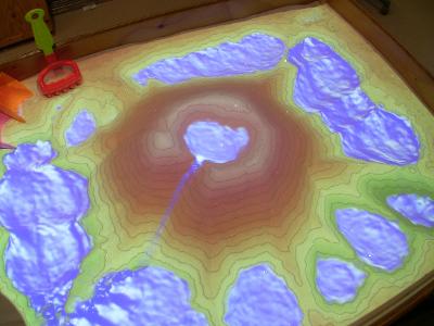
The resulting augmented reality (AR) sandbox allows users to create topography models by shaping real sand, which is then augmented in real time by an elevation color map, topographic contour lines, and simulated water. The system teaches geographic, geologic, and hydrologic concepts such as how to read a topography map, the meaning of contour lines, watersheds, catchment areas, levees, etc.
via Neatorama
April 7, 2013
featured blogs
May 2, 2024
I'm envisioning what one of these pieces would look like on the wall of my office. It would look awesome!...
Apr 30, 2024
Analog IC design engineers need breakthrough technologies & chip design tools to solve modern challenges; learn more from our analog design panel at SNUG 2024.The post Why Analog Design Challenges Need Breakthrough Technologies appeared first on Chip Design....