


I’ve just been introduced to a new technological concept and capability I’d never even contemplated before, and now my poor old noggin is buzzing with ideas. Let me set the scene. Suppose you were to wake up in a huge cavern at the bottom of the world’s deepest mine (I hate it when that happens). Also, suppose there are multiple tunnels leading off in all directions, but there are no signs indicating which one you should take to escape.
Fortunately, a kindly soul has taken the time to leave a lamp and a piece of paper that reads, “The tunnel at 120° leads to the surface; all the other tunnels lead to certain death.” Obviously, a great big arrow painted on the floor pointing to the exit tunnel wouldn’t have hurt, but we’ll take what we can get.
I know this sounds a bit like a game of Dungeons & Dragons, but bear with me for a moment if you will. In the center of the cavern is a device, which is fixed to the floor (so we can’t move it). This device is currently powered off. Suppose we power it up and (by means of some form of display), it provides us with sufficient information for our purposes, such as accurately indicating North to within a fraction of a degree, from which we can easily derive the 120° angle necessary to identify our tunnel of interest.
You will just have to take my word for it that this device is completely self-contained; it has not been pre-programmed with a direction, and it is not receiving signals from any external electronic infrastructure sources (e.g., radio/beacon-based positioning systems), so how is it performing its magic?
“Ah ha,” you might say, “it obviously contains a 3-axis magnetometer.” Well, that may be true, but it’s not something upon which I would care to risk my life. Mines often contain large amounts of ferromagnetic material (iron ore, steel support beams, machinery…). These distort the Earth’s magnetic field, causing local anomalies that make readings unreliable. Rock strata with varying mineral content produce magnetic gradients that can cause unpredictable shifts in readings. In some ore-rich mines, the local magnetic field is so strong that it overwhelms the natural geomagnetic signal.
“Well, maybe it contains a 3-axis gyroscope and a 3-axis accelerometer,” you might argue. Once again, this may be the case, but what good does that do us here? A 3-axis gyroscope can measure angular velocity (how fast something is rotating) in the X (roll), Y (pitch), and Z (yaw) axes. Meanwhile, a 3-axis accelerometer can measure linear acceleration (change in velocity) in the X (forward-back), Y (left-right), and Z (up-down) axes. However, this depends on them moving, and—as we have already stated—the device in our imaginary scenario is firmly fixed to the floor.
Hmmm, a conundrum indeed.
I’ll leave you to ponder this poser for a moment. All will be revealed shortly (I hope you don’t mind me calling you “Shortly”). But first, let me say that when someone starts bending my ear about navigation systems (not that this occurs on a daily basis, you understand, but it certainly happens more often than it used to), I’m not always as enthusiastic as they might perhaps hope. However, when they add that their technology is also heading to the Moon, it must be acknowledged that my ears tend to prick up a little.
Before we plunge further into the fray with gusto and abandon (and aplomb, of course), let’s make sure we are all tap-dancing to the same skirl of the bagpipes.
When I was in the scouts, which is many moons ago as I pen these words, we navigated using magnetic compasses in conjunction with printed maps. There are multiple potential problems with this approach (which is my excuse for never actually ending up where I intended to be), not least that any readings can be disturbed by local magnetic anomalies.
While compasses may be “good enough for government work,” as they say, it’s more than a tad disconcerting to discover that the magnetic north and south poles don’t line up with their geographic “spin-axis” counterparts.
At the time of this writing, the approximate location of the magnetic north pole is 86°N latitude, 138°E longitude (near Siberia), which puts it around 240 miles (386 kilometers) from its geographic counterpart. Meanwhile, the approximate location of the magnetic south pole is 64°S latitude, 135°E longitude (off the coast of Antarctica), which is approximately 1,775 miles (2,860 kilometers) from its geographic namesake. The reason I qualified these statements with the weasel words* “At the time of this writing” is that these locations are not fixed: the magnetic north pole is drifting toward Siberia at up to 55 km per year, while the magnetic south pole is moving northwest at about 10–15 km per year (*remember that eagles may soar, but weasels rarely get sucked into jet engines).
Magnetic compasses remain useful and relevant as a simple, low-tech, and often reliable navigation tool—but for precise navigation, especially over long distances or in environments with high magnetics and/or electronics density, they are usually supplemented (or completely replaced) by a global navigation satellite system (GNSS), such as GPS (USA and others), GLONASS (Russia), Galileo (European Union), and BeiDou (China), plus regional systems like NavIC (India) and QZSS (Japan).
Today’s GNSS receivers are typically multi-constellation and multi-frequency, combining signals from multiple systems. The big problem with satellite systems is GNSS denial, which means a receiver can’t access or use satellite navigation signals. This can occur for various natural, technical, or intentional reasons, including environmental causes (obstruction by tall buildings, mountains, dense forests…), multipath interference (signals bouncing off buildings, cliffs, metal structures…), space weather (solar flares), and atmospheric effects (heavy ionospheric or tropospheric disturbances can degrade accuracy).
When faced with a GNSS denial situation—like finding ourselves underground in a mine, for example—we are obliged to rely on an inertial navigation system (INS), which estimates the position, velocity, and orientation of a vehicle or object without relying on external references. An INS works by measuring acceleration and rotation and then integrating those measurements over time to compute position and orientation.
The main components of an INS are an inertial measurement unit (IMU) that utilizes accelerometers and gyroscopes to measure acceleration and rotation rates, respectively, and a processing unit that interprets all the data coming from the sensors. The IMU may also contain magnetometers that measure the strength and direction of magnetic fields. For the purposes of these discussions, we will assume the use of 3-axis accelerometers, gyroscopes, and magnetometers.
For the type of navigation tasks we are considering here, an INS is typically aided by additional sensors, including GNSS, barometers, and odometers, among others.
The problem with all of this is that each sensor has its own strengths and weaknesses, which may vary in importance on a second-by-second basis depending on events unfolding in the surrounding environment.
Sensor fusion is a process that combines data from multiple sensors to produce a more accurate, reliable, and comprehensive understanding of the environment or a system than any single sensor could provide independently. This is achieved by leveraging the strengths of different sensors to overcome their limitations, providing benefits such as enhanced perception, improved accuracy, increased robustness against sensor failures, and better overall system performance.
All of this brings us to a very interesting Australian company called Advanced Navigation. In 2008, one of the co-founders, Xavier Orr, was studying at university when he discovered all navigation systems were using an algorithm from 1967, known as the Kalman filter. He set about working on his thesis, which explored a neural network approach to navigation. Together with the other co-founder, Chris Shaw, the two commercialized the research. In 2012, Advanced Navigation was founded based on this technology.
Although the use of AI seems obvious to us today, this application was revolutionary at the time. If we fast-forward to the present, we find that the guys and gals at Advanced Navigation have expanded their footprint across the globe. Their proprietary AI-based fusion algorithms utilize artificial neural networks (ANNs), specifically long short-term memory (LSTM) networks, to process and combine data from various sensors, including accelerometers, gyroscopes, magnetometers, and GNSS receivers.
I was just chatting with Matthew Suntup, who is a Senior Application Engineer at Advanced Navigation. We started by discussing their ultra-high-performance Boreas IMUs, which utilize cutting-edge digital fibreoptic gyroscope (DFOG) technology.
FOGs come in different flavors: tactical-grade (used in drones, missiles, and vehicles), navigation-grade (used in aircraft, ships, and high-precision robotics), and strategic-grade (used in submarines, spacecraft, and long-endurance systems). Of course, the crème de la crème are the strategic-grade units, and Boreas IMUs fall into this category, providing exceptional accuracy and reliability under all conditions, with no reliance on GNSS.
Now, sit up and pay attention, because this part is really clever. The FOGs used in Boreas IMUs are so sensitive and accurate that they can detect the Earth’s rotation, which is 15 degrees per hour. Since they boast 3-axis DFOGs, this means that, from the get-go, the IMU immediately knows which way it’s pointing, even when it’s deep underground, like in a mine. This is, of course, the answer to the problem we posed at the beginning of this column.
Things get better because every gyroscope on the planet suffers from drift to a greater or lesser extent. MEMS gyros are small and inexpensive but have relatively high drift rates. Larger, mechanical gyros also drift due to friction, bearing imperfections, and mechanical wear. They are better than MEMS, but not as good as high-end FOGs, which can have drift rates measured in fractions of a degree per hour.
Did I just say, “Every gyroscope on the planet”? Silly me. I meant to say, “Every gyroscope on the planet except the DFOGs used in Boreas IMUs.” Since these can detect the rotation of the Earth, they have an external reference point, which means they aren’t subject to drift.
Let’s take a moment to read that again. The DFOGs used in Boreas IMUs are not subject to drift. If you are in the business of navigation, then this is HUGE!
But wait, there’s more, because the chaps and chapesses at Advanced Navigation recently introduced a new laser velocity sensor technology that measures velocity in three dimensions by detecting the Doppler shift of lasers bouncing off a surface. This is similar to police radar, but with much higher accuracy. This sensor provides precise velocity measurements relative to the ground (and walls and ceiling in the case of a mine), which is then fed into the inertial navigation system as an additional source of data.
In fact, folks at Advanced Navigation successfully demonstrated a breakthrough in underground navigation, delivering high-precision positioning without reliance on fixed infrastructure or GNSS, in one of the world’s deepest underground mines at Pyhäjärvi, Finland. This hybrid navigation system, combining a laser velocity sensor (LVS) with the Boreas DFOG-based INS, achieved consistent sub-0.1% navigation error across multiple runs, without relying on any fixed positioning infrastructure, pre-existing maps, or external aiding.
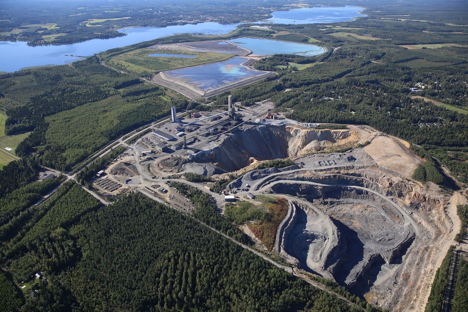
Aerial view of Pyhäsalmi Mine in Pyhäjärvi, Finland (Source: Advanced Navigation)
To provide a visual depiction, they first created a 3D LiDAR scan of the mine, spanning 22km of tunnel and plunging to a depth of 1,400m. The video below presents the results of this hybrid navigation system in comparison to an alternative high-end system, as shown in the context of the LiDAR scan.
I can barely contain my excitement, because there’s even more to tell. Navigating on the Moon is far trickier than on Earth, because so many of the systems we take for granted (GPS, magnetometers, atmospheric cues) either don’t exist or behave differently.
Let’s not even think about the problems of working on the surface or working underground in lava tubes and caves—just landing in the right place involves multiple challenges, including the following:
- No GNSS/GPS: There’s currently no global satellite navigation system around the Moon, so landers cannot rely on GPS for positioning.
- Low visual contrast: Lunar terrain is covered with regolith and has few distinctive landmarks, making visual navigation difficult.
- Communication delays: Remote operation from Earth introduces a ~1.3-second one-way delay, preventing real-time corrections.
- Inaccurate altimetry: LiDAR or radar altimeters help, but small errors can cause large positional deviations during descent.
- Dust and regolith plumes: Rocket exhaust can kick up dust during landing, interfering with optical sensors.
All this goes to explain why Advanced Navigation’s LUNA (Laser measurement Unit for Navigational Aid) is set to fly aboard Intuitive Machines’ Nova-C lander on its fourth Moon mission, which is scheduled to launch in 2027.
LUNA is a space-qualified laser-based navigation sensor that delivers precise 3D velocity and altitude data relative to the lunar surface. It’s designed to function even when visual references are unavailable—such as in darkness, dust, or low-light conditions. In fact, it’s the technology underlying LUNA that was subsequently adapted for Earth-based applications, such as the aforementioned LVS used in the mining application presented earlier.
As I said at the beginning of this column, all of this has left my poor old noggin buzzing with ideas. How about you? Do you have any thoughts you’d care to share on anything you’ve read here?


What an intriguing read! Underground and the Moon may be polar opposite environments but they face the exact same kind of navigation challenge I.e. no GPS. The task of simply knowing where you are and where you’re headed is incredibly hard – imagine you’re a 100 ton truck or spacecraft navigating in complete darkness… validated technologies like the one described here show there are ways to get around (reliably and precisely) without using GPS. The next step is introducing them to the industries that need it, and it seems like Advanced Navigation is already way ahead given they are planning to establish new centers of excellence around the world https://www.advancednavigation.com/news/advanced-navigation-expands-across-us-and-europe-to-meet-surging-demand-for-pnt-technology/